BACK TO RESEARCH WITH IMPACT: FNR HIGHLIGHTS
The health of terrestrial ecosystems is intricately linked to the sustainability and stability of society: forests, grasslands, and cropland, play a crucial role by providing essential services such as climate regulation, carbon sequestration, and food supply. Researchers are supporting policy making and environment management by developing and finetuning the way these systems are monitored.
Monitoring terrestrial ecosystems effectively and efficiently is crucial for understanding how they respond to stress and for addressing climate change. This helps guide policy decisions and environmental management.
Remote sensing – hands-free information about the Earth
Looking at ecosystem processes closely, such as plant evapotranspiration and photosynthesis, is important to assess the well-being of terrestrial ecosystems. Remote sensing – the use of sensors on satellites, drones, or aircraft to gather information about the Earth without touching it – is an effective way to observe terrestrial ecosystems at large spatial scales. By providing valuable data on vegetation conditions, remote sensing enables the detection and monitoring of changes in terrestrial ecosystems.
“Research in remote sensing of terrestrial ecosystem processes has significantly advanced our monitoring and understanding capabilities of these ecosystems. Over the years, a range of Earth Observation satellite missions have been launched to collect invaluable time-series data. ”Dr Tian Hu Remote sensing scientist, Senior Research and Technology Scientist at Luxembourg Institute of Science & Technology , and Principal Investigator (PI) on a CORE Junior project.
“These missions span from the pioneering the TIROS missions in the 1950s and 1960s, to the highly successful NASA Earth Observing System (EOS) launched in the late 1990s and early 2000s, as well as the reputable ESA Sentinel series missions starting from 2014 under the Copernicus programme. These observations serve as a solid foundation for monitoring the terrestrial ecosystem processes.”
Additionally, the rise of several biophysical and biochemical models has made it possible to estimate levels of water, energy, and carbon fluxes in the land-atmosphere system. These models use data from satellites that measure land surface conditions in visible, near-infrared, and thermal bands, providing scientists with a better understanding of how ecosystems work.
Main challenge: Minimising the need for guessing
Still, there are challenges in the quest to accurately retrieve water, energy, and carbon fluxes in the terrestrial ecosystems: One example is a substantial reliance on essentially, guessing, when it comes to the modelling process of plant transpiration and photosynthesis.
“The intricate nature of these physiological processes, compounded by variations across diverse ecosystems and aridity levels, poses a considerable hurdle in establishing a standardized parameterization scheme applicable across different conditions.”
To address this challenge, developing new theories that can be applied to different ecosystems is key. While scientists are working toward resolving this issue, it remains a work in progress.
“This challenge persists due to a fundamental gap in understanding the intricate relationship between aerodynamic temperature and land surface temperature in the energy balance process. Additionally, the modelling process is hindered by insufficiently characterised constraints on biophysical conductances across ecosystems and climates. ”Dr Tian Hu Remote sensing scientist, Senior Research and Technology Scientist at Luxembourg Institute of Science & Technology
Better use of data to reducing the need for complex estimations
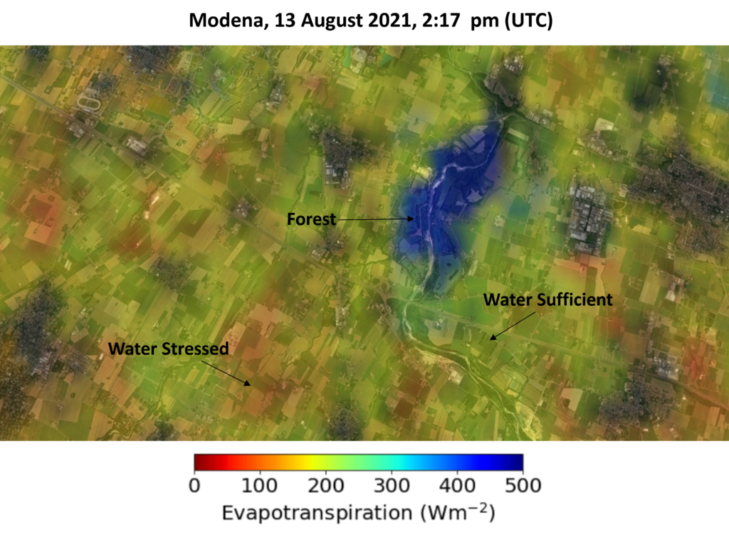
Tian Hu’s research focuses on improving ecosystem models by reducing the need for complex estimations. Using land surface temperature, obtained from thermal infrared data, water stress effects in evapotranspiration processes is included. Additionally, plant transpiration and photosynthesis are linked directly through the behaviour of stomata on leaves. Each plant leaf has thousands of stomata, when water enters a plant through the roots, it is evaporated via these little “plant mouths”.
By revisiting basic equations for airflow and energy transfer, the need to estimate temperature and resistance factors in evapotranspiration is avoided. The need for calculated leaf biochemistry is also eliminated, thanks to a direct estimation of plant photosynthesis rates from canopy water use.
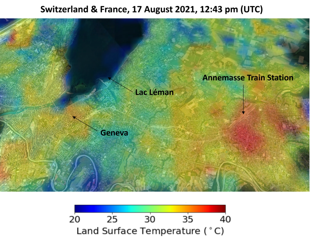
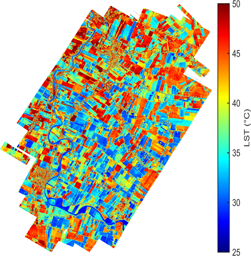
“Collaboratively with the team members, I have established a comprehensive production chain, seamlessly transitioning from thermal observations to land surface temperature and evapotranspiration within a unified and unparameterized framework. Leveraging this production chain, we have generated time series data of land surface temperature and evapotranspiration over Europe and Africa.”
Research outcome already in action
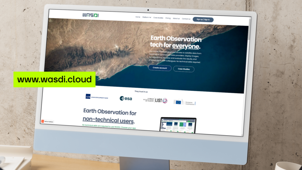
The resulting data are readily accessible to the public on the WASDI platform, a joint venture launched in 2020, between FadeOut Software (a software development SME in Italy), and the Luxembourg Institute of Science and Technology (LIST). The data have already been put to good use, for example to monitor agricultural drought over Africa and water resources management over Europe.
Furthermore, this production chain serves as a critical foundation for the European Space Agency (ESA)’s upcoming “Land Surface Temperature Monitoring” (LSTM) mission, as well as the joint satellite mission TRISHNA (Thermal infraRed Imaging Satellite for High-resolution Natural resource Assessment), a planned cooperative joint satellite mission between the Indian Space Research Organisation (ISRO) of India and Centre national d’études spatiales (CNES) in France.
Tian Hu is a remote sensing scientist, Senior Research and Technology Scientist at Luxembourg Institute of Science & Technology, and Principal Investigator (PI) on the FNR CORE Junior project ENCORE.
MORE ABOUT TIAN HU
Describing his research in one sentence
“Remote sensing of terrestrial ecosystem processes at high spatiotemporal resolution.”
On his journey to become a scientist
“From my childhood, I have been fascinated by the mysteries unfolding on the stars in the sky. This passion for stars and outer space led me to pursue a major (satellite remote sensing) related to the artificial ‘star’ in the university. During the years of undergraduate, I developed a strong interest in scientific research and environmental sciences. Thus, I delved deeper into this field and embarked on a journey towards a PhD programme, where I could merge my expertise in satellite remote sensing with my interest in terrestrial ecosystem monitoring. After my PhD in Australia, I seized the opportunity to work as a postdoctoral researcher in the REMOTE group at LIST in 2020, working on an ESA funded project that is perfectly aligned with my research background. This marked the start of my journey in Luxembourg, where I continue to explore the wonders of Earth observation.”
What he loves about science
“Science offers the opportunity to craft your won theories and unveil fresh discoveries. It is a realm where you can push the boundary of the current knowledge and broaden our comprehension of the world with your unique contributions. Engaging in scientific research not only enhances your logical reasoning skills but also emboldens to explore uncharted territories. The satisfaction derived from enriching humanity’s collective wisdom and making potential impact on prosperity and sustainability of our society is truly compelling.”
Where he sees himself in 5 years
“I am currently serving as a Principal Investigator (PI) in a funded FNR CORE Junior project. In addition, I am actively supervising master and PhD students, along with postdoctoral researchers. Balancing both roles as a scientist and supervisor brings me great satisfaction, and I find fulfilment in mentoring the next generation of researchers. As such, I envision myself continuing my career in research over the next five years, furthering my contributions to the field and nurturing the growth of emerging scientists.”
Mentor with an impact
“Upon joining LIST as a postdoctoral researcher, I had the privilege of collaborating with Dr. Kaniska Mallick, whose mentorship has profoundly influenced my scientific journey. Under his guidance, I gained invaluable insights into terrestrial ecosystems and cultivated a more rigorous scientific approach. Dr. Mallick imparted his expertise in utilizing biophysical models driven by remote sensing observations to understand plant physiological processes. Moreover, I learnt to conduct comprehensive analyses of experiment results across ecosystems and aridity levels. His unwavering dedication to scientific inquiry, steadfast work ethic, and infectious passion have left an indelible mark on my scientific mindset, shaping my attitude towards science for years to come.”
Why he chose Luxembourg for his research
“I arrived in Luxembourg as a postdoctoral researcher driven by my keen interest in the ESA-funded project ‘European ECOSTRESS Hub’. This project, focused on estimating land surface temperature and evapotranspiration across Europe and Africa using the high spatio-temporal resolution ECOSTRESS data, also aimed to pave the way for the future thermal high-resolution missions worldwide. Our successful outcomes led to additional financial support from ESA for the second phase of the project. Subsequently, I secured my own FNR CORE project. Through active involvement in these scientific endeavours, I gained insights into the vibrant scientific ecosystem of Luxembourg and Europe, appreciating the collaborative and open-minded scientific atmosphere. Moreover, I found Luxembourg to be a charming country, with its welcoming and friendly inhabitants. It is for these reasons that I made the decision to pursue my research endeavours in Luxembourg.”
Related Funding Instruments
Related highlights
Spotlight on Young Researchers: Lab-grown Cannabis Sativa for valuable compounds
Cannabis sativa is of great interest to scientists, with uses in areas including cosmetics, nutraceutics and pharma. Researchers are working…
Read more
Spotlight on Young Researchers: Making seawater drinkable
Water covers most of our planet, but only about 3% of it is drinkable and hard to reach for many…
Read more
Spotlight on Young Researchers: Smarter choices for complex systems
Complex systems are part of our everyday lives: smart cars, satellites, medical devices – but if they fail it can…
Read more
Spotlight on Young Researchers: Modelling Forest survival in a changing climate
Forests are dynamic ecosystems – they are used to change but it takes time to adapt. Climate change means drastic…
Read more
Spotlight on Young Researchers: Ensuring sustainable water use for Luxembourg
In Luxembourg, nearly one tenth of water consumption happens in agriculture. Changing rainfall patterns and rising irrigation needs during summer…
Read more
Spotlight on Young Researchers – Revisited: From researcher to project manager
When Xianqing Mao was featured in Spotlight on Young Researchers in 2017, she had completed her medical degree and was…
Read more