BACK TO RESEARCH WITH IMPACT: FNR HIGHLIGHTS
As the FNR marks 25 years since its creation, we highlight 25 examples of FNR-supported research with impact. Starting with his PhD in 1995, hydrologist Laurent Pfister’s research has been geared towards building a lasting research infrastructure for water resources related research in Luxembourg, with a focus on rivers and their watersheds.
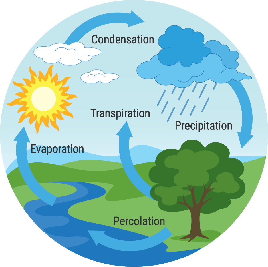
Rivers and their watersheds are key components of the Earth system. They are complex and constantly evolving, especially in response to work performed by physical and biological processes, as well as by humans. Rivers are often – mistakenly – thought of as rigid systems. Understanding how they respond to changes is an important factor in climate mitigation and adaptation measures.
“The detection of changes in the hydrological cycle and the identification of their causes is pivotal: documenting these changes lends confidence to model projections and helps developing more robust adaptation strategies to weather and climate extremes. However, extreme discharge statistics are an example of what is misleading, since they are often uncertain, as they may extrapolate 10 to 100 times beyond the length of too short and/or incomplete instrumental records. ”Laurent Pfister Head of the research unit 'Environmental sensing and modelling' (ENVISION) at the Luxembourg Institute of Science and Technology (LIST).
Fluvial history: Understanding how a river has flowed in the past
Besides being marked by flood anomalies – periods rich or poor in floods – the recent history of how a river has flowed, also called “fluvial history of rivers” is tainted by land cover changes: Pollen records show a massive human influence on vegetation cover in recent millennia, with the growth of agricultural land at the expense of forests. With farming accounting today for 70% of global water use, this evolution has led to considerable changes in green and blue water availability – aggravating water scarcity at global levels.
“The climate crisis is here – and with it the alternating pulse of river floods and droughts is undergoing irreversible changes. A major impediment to the design of precautionary measures against so-called ‘once in a lifetime’ flood and drought events is the flawed concept of rivers as static systems, with their properties, states, and processes remaining unchanged over time.”
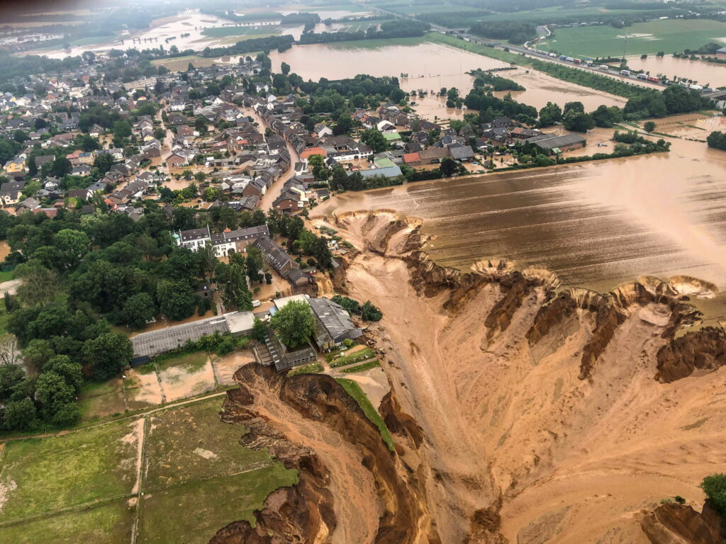
Last 30 years most flood-rich in 500 years
The last three decades are amongst the most flood-rich periods in the last 500 years: The largest observed floods in major rivers in Europe such as the Rhine, Elbe, and the Danube occurred during this time.
“It is a daunting fact in this context that, according to extreme value statistics in operation, the catastrophic Ahr flood in July 2021, which was not far from Luxembourg, was a hydro-geomorphological event that occurs only once in 10,000 years, whereas historical records report similar floods for that same river in 1804 and 1910.”
These inconsistencies pose a significant challenge for hydrologists such as Pfister, mainly the question “How can qualitative terms such as ‘more frequent, less frequent, extreme’ be translated into trustworthy, quantitative probabilities?”
A new take on hydrology under global change
Watershed management is the process of taking care of the land and water in a specific area where all the water drains into the same place, like a river or lake. This includes activities to keep the water clean, prevent flooding, and ensure there’s enough water for everyone who needs it. This term is becoming more and more relevant for human health and safety. It requires long-term data on non-linear relations between climatic and human-driven forcing.
“Our research eventually provides a new take on hydrology under global change. We aim at improving our understanding why watersheds have evolved the way they did. This opens entirely new vistas for river system engineering and management, providing a conceptual foundation for testing innovative dynamic solutions prior to their implementation, such as landscape re-engineering scenarios and stream power duration curves. ”Laurent Pfister Head of the research unit 'Environmental sensing and modelling' (ENVISION) at the Luxembourg Institute of Science and Technology (LIST).
‘From stronger evidence, to informed decisions, for a better environment’
Pfister has been a hydrology researcher since 1995, when he started his PhD. Over the last 22 years in Luxembourg, Pfister has built a large research unit aiming for a holistic understanding – via interdisciplinary approaches – of intrinsically coupled hydrological and human systems in a context of global change and subsequent non-stationarity of environmental systems.
“From stronger evidence, to informed decisions, for a better environment’ stands as our tagline – eventually summarising our product portfolio. I have wired my research around the exploration of innovative and interdisciplinary research avenues for overcoming some of the most pressing technological limitations that have hindered progress in hydrological processes research and water resources management.”
“We steadily design, build and test new technological solutions for monitoring environmental systems that are increasingly put under pressure by global change.”
“We continuously explore opportunities for wiring our research into applied contexts. On a regular basis, we provide expert advice and services to public administrations and stakeholders in the field of global change impacts on water resources,for example for flood & drought management.”
Funded through an FNR Industrial Fellowship grant , involving POST Telecom and the ‘Administration de la gestion de l’eau’ (AGE), the research of A. Douinot (LIST) notably focused on the mechanisms controlling flash floods in Luxembourg – a type of extreme events that had until very recently been restricted to the Mediterranean area.
Read moreEarth Observation datasets for a clearer picture
The team develops innovative field deployable sampling devices, which deliver ecological and environmental data with unprecedented temporal and spatial resolution. Using the newest telecommunication technologies for deploying monitoring networks of unprecedented and flexible density, the team also relies on satellite and airborne Earth Observation (EO) technologies for collecting spatially continuous information of environmental variables, both on a global level as well as at ecologically and hydrologically relevant spatial scales and temporal resolution.
For decades, emergency responders lacked a fully automated global flood mapping service due to various technological limitations. Under the supervision of P. Matgen (LIST), FNR-supported projects like HYDRASENS, PAPARAZZI, and MOSQUITO helped to overcome these obstacles – leading to the development of efficient satellite data classifiers for various terrains. Now operational on platforms like the Copernicus Emergency Management Service, these advancements enable a fully automated global water body mapping.
Research highlight: Uncovering patterns in Luxembourg’s Alzette River Basin
In 1990s, a dense and nested hydro-meteorological monitoring network was set up in Luxembourg’s Alzette River Basin. In an FNR CORE project (STORE-AGE), Pfister and team discovered not only that the streamflow response across 16 nested catchments was highly variable, but also that this variation was very much linked to their underlying geology: permeable (‘spongy’) bedrock sites typically stored large amounts of water and delivered a reduced feed of water to the stream, and that this water is several years to decades old.
On the contrary, catchments where the bedrock was less permeable had a much more limited storage capacity. This leads to a more immediate response to rainfall, with ‘younger’ water released into the stream, as well as a limited resilience to dry periods.
“The knowledge of bedrock influence on river basin response will greatly assist water managers in Luxembourg to tackle the increasing pressures on water resources. As a follow-up to these investigations, a national isotope monitoring programme was initiated jointly between LIST and the National Water Agency. This research has gained further momentum through the DFG-FNR funded CAOS project – ‘Catchments as organised systems’ which ran from 2015 to 2018 – and was led by Prof. Erwin Zehe (Karlsruhe Institute of Technology, Germany). ”Laurent Pfister Head of the research unit 'Environmental sensing and modelling' (ENVISION) at the Luxembourg Institute of Science and Technology (LIST).
The resulting paper ‘Bedrock geology controls on catchment storage, mixing, and release: A comparative analysis of 16 nested catchments’ [Pfister et al., 2017; https://doi.org/10.1002/hyp.11134] received the an FNR Award in the category Outstanding Scientific Publication in 2020.
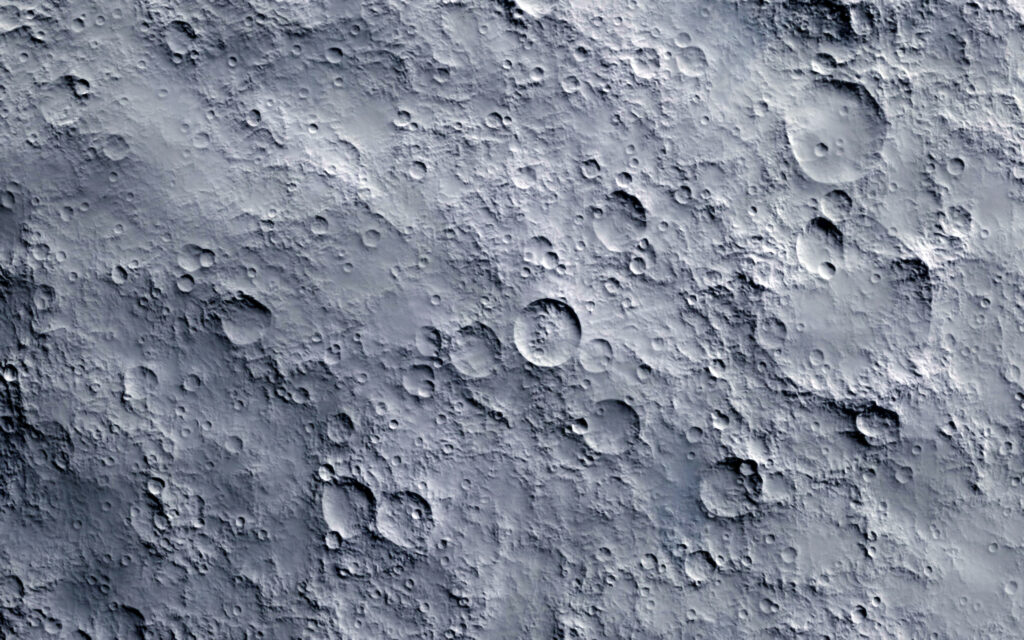
Research highlight: Prototype paves the way looking at Moon processes
Through the projects FieldSpec and FieldSpec PoC that Pfister co-led with Dr. Tom Wirtz (LIST), experts in hydrology and mass spectrometry teamed up in a unique consortium, exploring the potential for a new generation of small-sized mass spectrometers for field-based isotope detection of O and H in water at high frequencies.
“These FNR-funded projects covered three distinct phases, including the design of a portable field mass spectrometer prototype, prototype testing in lab conditions and outdoor prototype testing.
“These developments eventually paved the way for LIST’s participation in exploratory work (with participations in science teams at ESA and NASA) on ice sublimation and O and H isotope fractionation processes on the Moon in the framework of the ESA and FNR supported ISOMOON and LUNAQUA projects.”
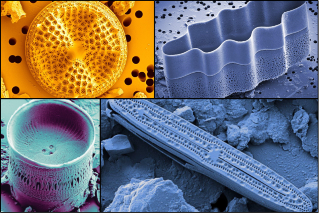
Research highlight: Diatoms shed new light on connections between water in streams, riverbanks and higher ground areas
An area of focus for the team’s research is measuring and characterising water flow and storage on hillsides and in larger drainage areas, however limited measurement techniques pose a challenge. The team is restricted by the types of geochemical and isotopic tracers they can use to identify where the water comes from and how different parts of the area connect to the stream.
“Together with experts in diatom ecology L. Ector and C. E. Wetzel (LIST), I have investigated since 2009 the potential for drift diatoms to shed new light on streamflow generation studies. Our pilot work revealed that such diatoms may provide a fundamental new way to assess the geographic sources of water at the watershed scale.”
The team also evaluated the uncertainties in estimating water sources using end member methods, measuring how well drift diatoms can detect when surface runoff starts and stops. Additionally, they looked at how these diatoms can show the connections between water in streams, riverbanks, and higher ground areas at different times and places.
“We also assessed the uncertainties in end member-based estimates of water sources and quantified the potential for drift diatoms to identify the on/off setting of surface runoff and hydrological connectivity between the aquatic, riparian and upland zones across different spatial and temporal scales. In 2016, this work on ‘Hydrological connectivity inferred from diatom transport through the riparian-stream system’ led by N. Martínez-Carreras (LIST) received the ‘Jim Dooge’ best paper award in the journal Hydrology and Earth System Sciences.[https://doi.org/10.5194/hess-19-3133-2015]. ”Laurent Pfister Head of the research unit 'Environmental sensing and modelling' (ENVISION) at the Luxembourg Institute of Science and Technology (LIST).
Research highlight: Pilot study using bivalve shells shows damping of precipitation signal
Another area of research relates to the need for long records of delta-18-O – a measure used in isotope geochemistry to express the ratio of the stable oxygen isotopes in a sample compared to a standard. The challenge is getting a combination of these numbers with long precipitation and stream water data series – the latter serving for the determination of water ages or travel times.
“This stands as a crucial problem in hydrology and environmental sciences. Making progress on this issue is a grand challenge for unveiling potential shifts in streamflow generation processes and anticipating how flowing waters will respond to global change.”
“Together with experts in sclerochronology (Prof. B. Schöne, Uni. Mainz) and nano-probing (N. Valle, LIST) we proposed an innovative contribution for solving the problem of limited stream isotope records: freshwater bivalves as long-term stream water delta-18-O recorders.”
In a pilot study funded by the FNR and the German research foundation (DFG), the international team analysed data from bivalve shells (delta-18-O data compiled from 10 studies), spanning a latitudinal sequence of 18 sampling sites on 16 streams around the globe [Pfister et al., 2019; https://doi.org/10.1038/s41598-019-40369-0].
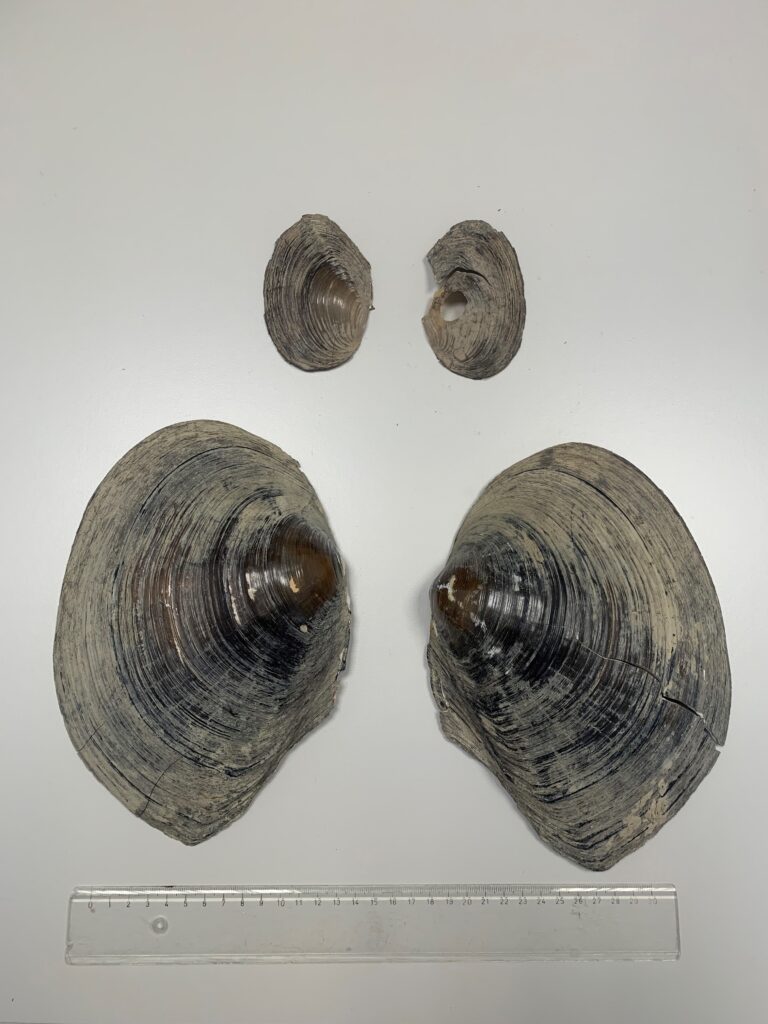
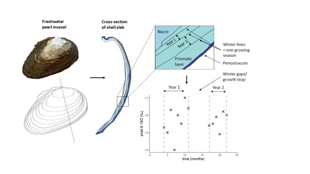
“We found strong links between isotope signatures in precipitation, stream water and freshwater molluscs. Both stream water and molluscs showed a strong damping of the precipitation signal. As part of our preliminary work, we also carried out a new, high-resolution reconstruction of stream water using shells of freshwater pearl mussels, Margaritifera margaritifera, from three rivers in Northern Sweden.”
[Schöne et al., 2019; https://doi.org/10.5194/hess-24-673-2020].
The importance of an interdisciplinary approach
Pfister stresses the importance of taking an interdisciplinary and collaborative approach to science, an important aspect of creating a strong and lasting infrastructure.
“My efforts have been relentlessly geared towards building a lasting research infrastructure in water resources related research in Luxembourg. In nearly 30 years, I have learned – as a hydrologist – to value partnerships with colleagues from other fields and disciplines. The widely expressed need in hydrological sciences for a paradigm shift from one that is dominated by ‘calibration’ or ‘hydrograph mimicking’ to one based on ‘understanding’ can only be achieved by truly interdisciplinary research going well beyond mere ‘discipline hopping’. ”Laurent Pfister Head of the research unit 'Environmental sensing and modelling' (ENVISION) at the Luxembourg Institute of Science and Technology (LIST).
Future challenges: ‘No man ever steps in the same river twice, for it’s not the same river and he’s not the same man.’
“I take inspiration from Heraclitus’ quote ‘No man ever steps in the same river twice, for it’s not the same river and he’s not the same man.’ Human impacts on the environment have reached critical levels in recent years, suggesting that the Earth is now largely outside its safe operating space. Humankind is de facto facing a climate emergency.”
“The risk of redistribution of blue water, such as that in rivers and groundwater, and green water – for example from plant transpiration and soil water – driven by climate change and demographic growth poses a threat to nearly three billion people and manifold ecosystems across the globe. Failure to anticipate and act on these menaces will eventually aggravate eco-hydrological and economic challenges in the coming years and decades.”
Rivers’ and watersheds’ complexity underappreciated
It is widely accepted that several dynamic factors – including population growth and economic development – need to be accounted for in climate and land cover change impact studies. Nevertheless, rivers and their watersheds are still treated as rigid and time-invariant systems.
“The Earth system is intrinsically complex, and its numerous mechanisms and processes operate from seconds to hundreds of millions of years. This is in stark contrast to the 200-300 years of instrumental records available at best in watersheds: they span only the last two percent of the Holocene – more or less the past ~11,700 years. More complexity is added by human activities that have profoundly impacted watersheds over the past centuries. These recent changes exceed the natural window of variability in environmental conditions that prevailed during most of the Holocene.”
Key question for the future: Understanding how global change will progressively modify watershed functions and ultimately change the pulse of rivers
The ‘synthesis of Newtonian and Darwinian worldviews’ has been advocated as the way forward in hydrological sciences, with the Newtonian approach to hydrologic science typically relying on a vast body of experimental and field research, serving often isolated mechanistic process descriptions that are wired into physically based models of hydrological behaviour.
“While this work has led to profound insights into the spatial and temporal distribution of fundamental hydrological functions, it leaves us with limited capacity to understand how a given watershed has developed and how it may evolve in the future. Rather than focusing on mechanistic descriptions of hydrologic processes, the Darwinian approach seeks to develop a theory of pattern formation in hydrologic systems and its adjustment through time. Key to success is the investigation of rarely recorded historical developments of processes and events that may have caused regime shifts – as opposed to research only focusing on contemporary properties and quasi steady-state behaviour. ”Laurent Pfister Head of the research unit 'Environmental sensing and modelling' (ENVISION) at the Luxembourg Institute of Science and Technology (LIST).
The changing pulse of rivers
For Pfister, the key question for the coming decades is how global change will progressively modify watershed functions and ultimately change the pulse of rivers. His ambitions have three strands: firstly, to expand hydrological chronologies into pre-instrumental times for assessing historic pulses of rivers; secondly, to assess current variability and diversity in eco-hydrological processes against historical watershed development; and finally to develop and apply an innovative physical and eco-hydrological modelling framework capable of explaining the processes and principles underlying the past, present, and future co-evolution of river systems, landscape features and ecosystems.
Overcoming data and knowledge gaps
“I believe our research to be strategically timed because we leverage a blend of pioneering concepts and technical advances – many of them developed and championed together with our partners – for overcoming the data and knowledge gaps, as well as the outdated rigid standard in watershed conceptualisation.
“By joining our expertise, skills, and technical resources, we can address pressing questions such as ‘how much did watersheds and rivers evolve in the past and how did this modify their functioning?’, ‘what mechanisms and principles are involved in their evolution and how large are anthropogenic influences?’, and ‘what trajectories will they follow in the future?’. Answers to those questions, for example, in paleohydrology and quantitative hydrological history fit into engineering requirements for flood risk assessment in the European Union – informing stakeholders in water resources management.”
Laurent Pfister on the difference the FNR has made
“I am firmly convinced that the investments made over the last 25 years by the FNR and the public authorities in research on environmental systems will undoubtedly be of great benefit to future generations of scientists and engineers who will have to face the considerable challenges posed by global change in the years and decades to come.”
“The FNR has been pivotal in providing funding for research questions and technological problems that were highly risky when they were first introduced into a competitive funding programme (e.g., using microwave antennas for measuring rainfall, building a small-sized portable field deployable mass spectrometer, using freshwater bivalves as natural recorders of stream water d18O). Much of this exploratory work has been leveraged in follow-up projects for testing new hypotheses on hydrological system response to environmental change. Through related proof-of-concept work and preliminary data, the FNR has thus paved the way for successful applications in competitive national and international research funding programmes.”
“Receiving the FNR award for our scientific publication on bedrock geology controls on hydrological functions during the Covid-19 pandemic was a very special moment. The ceremony taking place at home in presence of my wife and son during a virtual ceremony was quite unique – standing as a beautiful and festive moment in otherwise rather gloomy times.”
Laurent Pfister on PhD researchers
“The scientific contributions listed here have relied on several generations of young scientists that have prepared Master and PhD theses within my research team. I am convinced that a long-term response to the challenges inherent to global change consists in training the next generations of urgently needed experts with interdisciplinary skills. A doctoral training unit in hydrological sciences (Hydro-CSI, funded by FNR) that I have been recently coordinating is a telling example in this respect. Partner institutions of Hydro-CSI and its 14 PhD projects were the University of Luxembourg, TU Vienna (A), KIT Karlsruhe (D), and Wageningen University (NL). To date, out of 11 defended PhDs, 4 candidates pursue their careers in academia (in the UK, Germany, Austria, and Japan), 4 work for private companies (3 in Luxembourg, 1 in Italy), 1 has joined an RTO in Finland, and 1 is working for a public authority in Belgium. These figures underline the employability of the doctoral degree holders that have emerged from this training programme.”
“A specific example of how PhD research can trigger manifold follow-up research avenues relates to thermal IR imagery. We have been the first to propose this as a new technique for monitoring hydrological connectivity at the soil surface through the PhD project of J. Frentress (Oregon State University, USA) in 2010. As a complement to stable isotopes of O and H, or geochemical tracers, IR cameras deliver high-resolution thermal imagery of saturated areas for identifying, characterizing, and classifying surface runoff in the hillslope-riparian-stream continuum.
“Our proof-of-concept work [Pfister et al., 2010; https://doi.org/10.1002/hyp.7840] demonstrated that this is a simple, inexpensive technology for sequential mapping and characterisation of surface saturated areas and a useful complement to conventional tracer techniques. This work was subsequently taken up in follow-up projects (e.g., FP7-PEOPLE-2013-ITN – Marie-Curie Action: ‘Initial Training Networks’, project INTERFACES: ‘Ecohydrological interfaces as critical hotspots for transformations of ecosystem exchange fluxes and biogeochemical cycling’; https://cordis.europa.eu/project/id/607150) and was a pivotal element of PhD research projects of Marta Antonelli [e.g., Antonelli et al., 2020; https://doi.org/10.1002/hyp.13698] and Barbara Glaser [Glaser et al., 2018; https://doi.org/10.5194/hess-22-5987-2018].”
Laurent Pfister on international collaboration
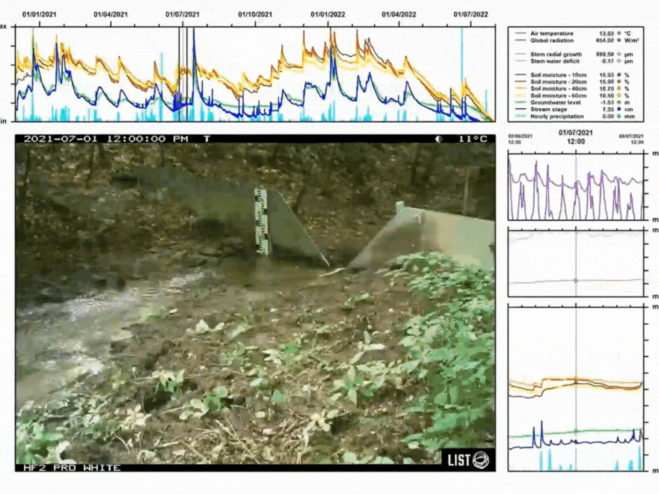
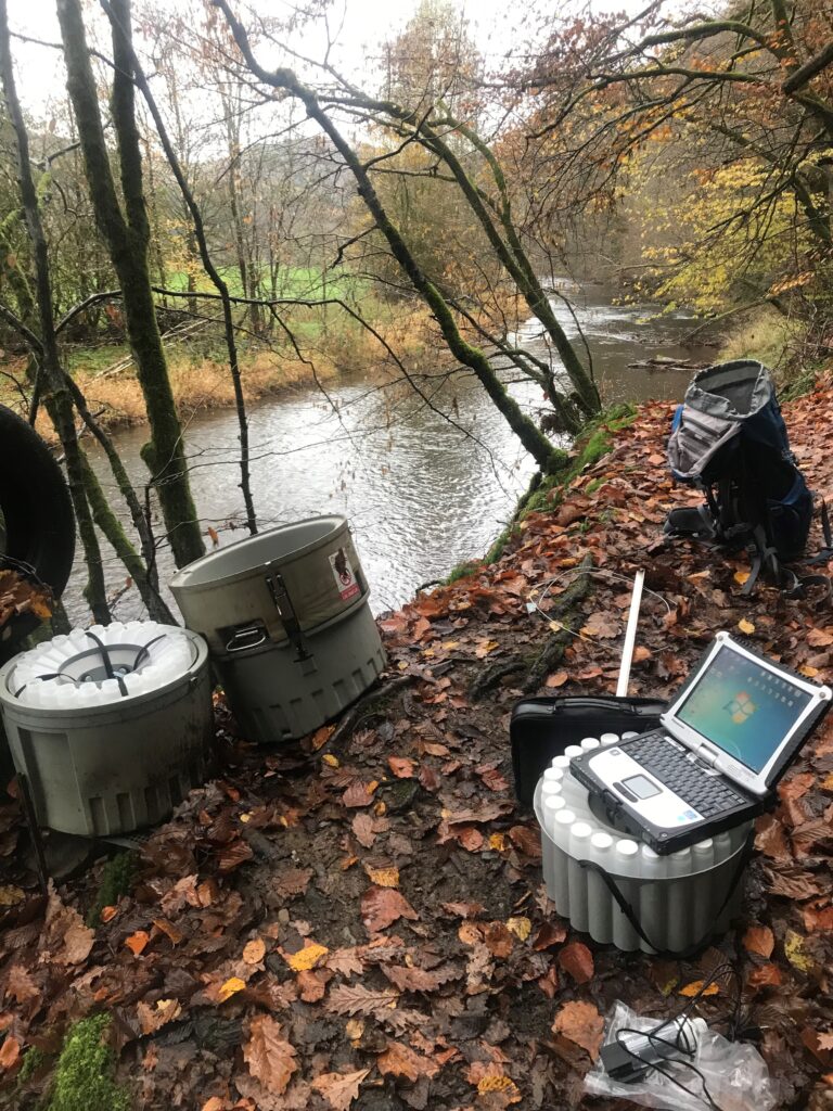
“Over the past 25 years, I have coordinated nearly 40 applied and fundamental research projects – many of them funded through the FNR and introducing innovative technologies for overcoming limitations in water resources research and management (e.g., cell phone microwave links for measuring rainfall, portable mass spectrometer for high-frequency analysis of O and H isotopes in water, terrestrial diatoms as hydrological tracers, and more recently – in collaboration with Bernd Schöne (Uni. Mainz) – freshwater bivalves for reconstructing d18O signatures in stream water). The implementation of these research activities largely relies on a series of core field and laboratory infrastructures that I have been advocating for and contributing to implement for nearly two decades at the Luxembourg Institute of Science and Technology (LIST). A major pillar in that respect is the hydro-meteorological monitoring network (including meteorological stations, streamgauges, automatic samplers, etc.) in the Alzette and Sûre River basins in Luxembourg – consisting of ~50 nested catchments covering a wide range of spatial scales (0.47 – 2700 km2), as well as clean and mixed physiographical characteristics.
Laurent Pfister FNR-funded projects (main applicant)
| Project title | Call year | Funding instrument |
| Behaviour of O and H stable isotopes of the water molecule in lunar regolith | 2021 | CORE |
| Freshwater pearl mussels as stream water stable isotope recorders | 2020 | CORE |
| Vegetation effects on catchment travel times: Integration of ecohydrological separation in the Storage Selection (SAS) function framework | 2017 | CORE |
| Prof. J.J. McDonnell at LIST: leveraging past investments into innovative research avenues in hydrological sciences and creating new opportunities for research projects, publications and market solutions | 2015 | INTER Mobility |
| Towards a holistic understanding of river systems: Innovative methodologies for unraveling hydrological, chemical and biological interactions across multiple scales | 2015 | PRIDE |
| Exploring catchment functions of storage, mixing and release across space and time | 2014 | CORE |
| From Catchments as Organised Systems to Models based on Dynamic Functional Units | 2014 | INTER |
| AGU Chapman conference Spatial organization and complex behavior of in | 2014 | RESCOM |
| Eco-hydrological couplings for investigating streamflow generation processes | 2012 | CORE |
| From Catchments as Organised Systems to Models based on Dynamic Functional Units | 2011 | INTER |
| A new portable mass spectrometer for high frequency measurements of d2H and d18O ratios in H20 and d15N and d18O ratios in dissolved NO3: FIELDSPEC | 2010 | CORE |
| Combining biological, isotope and geochemical tracers to improve streamflow generation understanding | 2009 | CORE |
| Use of cell phone networks for rainfall estimation in the city of Luxembourg | 2008 | CORE |
| CLIMAT: Climate Change and Change in Land Use in Luxembourg | 2002 | VIVRE (former instrument) |
| Study of the Water Cycle Components in the Attert River Basin | 2001 | EAU (former instrument) |
Related highlights
Spotlight on Young Researchers: Reconstructing the history of flowing waters
The hydrological cycle – the continuous circulation of water in the Earth-Atmosphere system – is vulnerable to climate change, which…
Read more
Mäin Element: Laurent Pfister
Read more
Research trends: New models for extreme weather
As part of a new series, the FNR speaks to five experts about research trends in their domain. With climate…
Read more
Related highlights
25 examples of research with impact: Driving innovation in software engineering, security, and AI
As the FNR marks 25 years since its creation, we highlight 25 examples of FNR-supported research with impact. Since arriving…
Read more
25 examples of research with impact: The science of fairness – inside inequality
As the FNR marks 25 years since its creation, we highlight 25 examples of FNR-supported research with impact. Since arriving…
Read more
25 examples of research with impact: A solid foundation for artificial intelligence
As the FNR marks 25 years since its creation, we highlight 25 examples of FNR-supported research with impact. Artificial intelligence…
Read more
25 examples of research with impact: Smart materials for a sustainable future
As the FNR marks 25 years since its creation, we highlight 25 examples of FNR-supported research with impact. Since arriving…
Read more
25 examples of research with impact: Advancing AI and Computer Vision: From space tech to better healthcare
As the FNR marks 25 years since its creation, we highlight 25 examples of FNR-supported research with impact. Since arriving…
Read more
25 examples of research with impact: Understanding the evolution of the workplace in the digital era
As the FNR marks 25 years since its creation, we highlight 25 examples of FNR-supported research with impact. Active in…
Read more